

November 1, 2022
WESTAF: Have You Seen My Public Art?
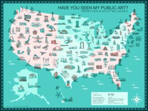
Have You Seen My Public Art? Map, 2nd Edition (2022), illustrated by Kara Fellows. Courtesy of WESTAF’s Public Art Archive™ Note: This map is an illustration. Artworks are not drawn to scale and their placements on the map may not be exact. For accurate information regarding artwork locations, we welcome you to engage with the interactive map to view the individual artwork detail pages.
Public art has many civic benefits. Aside from enlivening and beautifying public spaces, public art makes communities distinctive and attractive places to live, visit and do business. Whether supported through state percent for art policies or other programs, public art installations can serve as focal points for civic engagement. They create job opportunities for artists and suppliers, and many public art projects tell important stories about local history and culture.
For these and myriad other reasons, documentation and promotion of public art are important functions of the national Public Art Archive (PAA), created by the Western States Arts Federation (WESTAF). The PAA is a dynamic database of nearly 20,000 public artworks from across the United States. The database is built upon on records from public art organizations and artists, using the information to raise awareness about the value of public art and to promote best practices in public art and cataloging. Since the archive launched in 2010, descriptive text, images and multimedia files have been added to the collection at no cost to contributors. In addition to searching for artwork on the site, the PAA can also be used on mobile devices to map and guide tours of public art in local communities.
In 2022 the PAA project compiled a second edition of its celebratory Have You Seen My Public Art? map. The new interactive map includes 144 artworks across all 50 states created by more than 176 unique artists and studios, most within the past 10 years. To create the map, the PAA sent out a call inviting artists and organizations to submit their artworks to a juried competition for a place on the map. Once the submissions were adjudicated, images of the highest-ranked works were shared with Colorado artist Kara Fellows, who created miniature hand-drawn illustrations of each of the 144 selected artworks to be featured on the map. The PAA team also performed a data analysis of all the selected artworks, providing an interesting snapshot of patterns in public art by material, placement type and installation type (permanent or temporary). All 500+ submissions were added to the Public Art Archive so that they can be discovered and enjoyed by a wide audience. For further information, contact WESTAF Public Art Archive Manager Lori Goldstein.